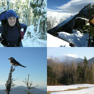
 Mt. Jefferson is the third tallest mountain in New Hampshire. It neighbors Mt. Washington, the tallest. Randy, Jodie, and myself attempted to climb Jefferson via the Castle Trail. The Castle Trail is a long route (5 miles) up Mt. Jefferson with 4200 feet of elevation gain. The Castle trail gets its name from several rock protrusions (Castles) along the ridge it climbs.
Mt. Washington had sent several records this month including most precipitation in a single storm and most snow in October. So, I expected to run into a fair amount of snow, but there was even more snow than I expected. There was about 3 inches on the ground at the trailhead and a couple feet around 4,000 feet. The snow was heavy and wet. It was a warm day. It was practically raining despite the clear blue sky because the snow was melting off the trees so quickly. The worst effect of the snow was the number of blow downs. It seemed like every few minutes we were going off the trail to go around another fallen tree. Needless to say, the going was tough and slow. Relatively early into the hike it became apparent that we didn’t have much of a shot at making the summit, but we were still interested in getting up high and getting a nice view. Around 12:30, after 3.5 hours of hiking, we reached a nice viewpoint just below the first Castle. We took a nice break here before heading back down. The viewpoint was very nice. It was warm, but a little windy. Two Grey Jays were trying to get our food. One landed on my outstretched hand. It must have thought I had something good in my hand, but it was empty. A lot of people must feed those birds for them to be so willing to get close to people.
It was nice to get up high even if we didn't make the summit. I've now hiked the entire Castle Trail. I had done the portion above The Link a few summers ago. Castle Ravine looks like an interesting place. I'll have to go there sometime.
Distance: 7.4 miles
Elevation Gain: 3000 ft
Time: 6.5 hours
No comments:
Post a Comment