Sunday, December 11, 2005

Mt. Jackson (4,052 ft) NH

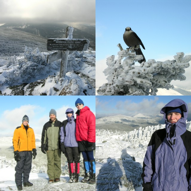
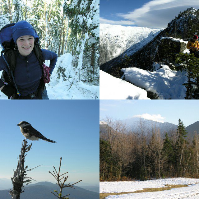
Randy, Joe, Jodie, and I climbed up Mt. Jackson today via the Webster-Jackson Trail. It was a great day. We had our first snowstorm of the season yesterday. In southern NH, we got over ten inches., but the northern part of the state got significantly less. At the trailhead in Crawford Notch, there was about three inches of fresh snow. The surprising thing was that there wasn’t any snow other than those three inches. I had expected to find a small snow base with a fresh layer on top, but apparently there hasn’t been much snow up in the mountains so far. Or at least nothing that has stayed on the ground. Hiking in fresh snow is always fun, and often the clear calm day after the storm offers incredible views. The day started out a little cloudy with breaks of sun, so I wasn’t sure we’d have the joy of seeing the sparkling sun on the fresh snow from the summit. By the time we reached the summit it had cleared considerably, and we got to see the great view towards Mt. Washington and of other surrounding peaks.

The weather was seasonably cold with very little wind on top. The trail is pretty moderate, alternating a few short steep sections with level and occasional descending sections. Right below the summit there is a short tricky section where the trail scrambles over some open ledges that were a little icy. There were some icy and tricky sections along the entire trail because the snow pack wasn’t there yet to smooth over the rocks. Overall it was a very fun day. It was nice to hike and group of 4. It is a good size.
Distance: 5.2 miles
Elevation Gain: 2200 ft
Time: 5.5 hours

Sunday, October 30, 2005

Mt. Jefferson (5,712 ft) Attempt, NH

Mt. Jefferson is the third tallest mountain in New Hampshire. It neighbors Mt. Washington, the tallest. Randy, Jodie, and myself attempted to climb Jefferson via the Castle Trail. The Castle Trail is a long route (5 miles) up Mt. Jefferson with 4200 feet of elevation gain. The Castle trail gets its name from several rock protrusions (Castles) along the ridge it climbs.

Mt. Washington had sent several records this month including most precipitation in a single storm and most snow in October. So, I expected to run into a fair amount of snow, but there was even more snow than I expected. There was about 3 inches on the ground at the trailhead and a couple feet around 4,000 feet. The snow was heavy and wet. It was a warm day. It was practically raining despite the clear blue sky because the snow was melting off the trees so quickly. The worst effect of the snow was the number of blow downs. It seemed like every few minutes we were going off the trail to go around another fallen tree. Needless to say, the going was tough and slow. Relatively early into the hike it became apparent that we didn’t have much of a shot at making the summit, but we were still interested in getting up high and getting a nice view. Around 12:30, after 3.5 hours of hiking, we reached a nice viewpoint just below the first Castle. We took a nice break here before heading back down. The viewpoint was very nice. It was warm, but a little windy. Two Grey Jays were trying to get our food. One landed on my outstretched hand. It must have thought I had something good in my hand, but it was empty. A lot of people must feed those birds for them to be so willing to get close to people.

It was nice to get up high even if we didn't make the summit. I've now hiked the entire Castle Trail. I had done the portion above The Link a few summers ago. Castle Ravine looks like an interesting place. I'll have to go there sometime.
Distance: 7.4 miles
Elevation Gain: 3000 ft
Time: 6.5 hours

Sunday, October 23, 2005

Mt. Carrigain (4,700 ft) NH

Jodie and I hiked Mount Carrigain via the Signal Ridge Trail yesterday. It was great! It was so nice to get a chance to go hiking again. It seems like it’s been raining forever. Last weekend, we had some major flooding in parts of the state. The stream crossings were still a little high, but not dangerously so, like I heard they were last weekend.

The Signal Ridge Trail is one of my more favorite trails. The trail is mostly flat for the first couple miles and then climbs at a constant, moderate grade. My favorite part is where it pops out onto the open area on Signal Ridge. The ridge drops off very steeply to the east, and offers great views of the slides on Mt. Lowell and to Mt. Washington. Mt. Washington and the rest of the Presidential Range looked surreal, capped with the season’s first major snow.

Carrigain’s summit has an old fire tower and offers 360-degree views. Carrigain is pretty much in the middle of the White Mountains so basically every major peak can be seen from the summit. The fall colors were past peak, but still provided nice contrast to the evergreens and snow-capped peaks.
Distance: 10.0 miles
Elevation Gain: 3200 ft
Time: 5 hours

Friday, October 07, 2005

Boulder Morty's, NH

Last night I went to Boulder Morty's Climbing gym in Nashua. It was a lot of fun. I hadn't been there in years, and it showed. Back when I was out in Wyoming for a semester, they had a climbing wall at the fitness center, and I would go a couple times a week. I got pretty good. Climbing often is key to developing the grip strength to pull on small holds. I went to Sinks Canyon one weekend and consistently top roped 5.9s cleanly. I even climbed a couple tens. It was a few years ago, and maybe my memory is being nice to me, but I don't remember falling at all there, except on a 5.11. Climbing last night felt good and bad. It felt nice because I still had most of the technique, but I clearly didn't have the strength I once did. I climbed a few 5.7s cleanly when I first arrived, but pretty soon, I got pumped out before reaching the top. I knew I could do the moves, it was just a matter of having the grip strength. The last few years have been very busy with work and class. I'm going to make climbing more of a priority from now on.

Wednesday, October 05, 2005

Mt. Nancy (3,926 ft) NH

I decided to go for a hike Sunday. I planned to hike to Nancy and Norcross Ponds with the BAE Outing Club in November and thought it would be a good idea to pre-trip that route. I tried to run as much as I could. I ran the first couple miles until the Nancy Cascades, where the trail becomes quite steep. I hiked up that section and then continued to run to the end of Norcross Pond. There is a gorgeous view from the ledges at the end of Norcross Pond. It took me about an hour to reach this point. I looked around a little bit and found a rather obvious trail towards Mt. Nancy. The trail is almost more obvious than the real trail when hiking east. I started following the trail and soon came across a National Forest Service sign indicating this was an unmaintained trail. The trail soon became very steep as it climbed pretty much straight up the peak. It reminded me of some of the steep trails we took in the North Cascades during my NOLS course. Most of the steep trails through the woods in the Cascades that I remember were steep descents. Ascending is tough, but the steep descents, like the knee-busting descent of Kindy Ridge, with 50-70 pounds are much tougher. Coming down from the summit of Nancy was steep and tough going, but not too bad because I didn’t have much of any weight on my back. The trip back to the trailhead was fine. I ran most of the way. I only hiked some of the steepest sections. I had several minor tweaks of my ankles and one fairly descent twist to my left ankle that almost caused me to fall down. Fortunately, the twist didn’t do much damage. Running up the trail was harder than I anticipated. The whole trip was a lot of fun. The running was a nice change of pace from the roads. I had to pay more attention to my feet than normal. Sometimes, particularly when descending, it took more effort to keep my feet moving quickly over the uneven terrain than the actual running. The entire trip was 2 hours and 40 minutes. I think I found the beginning of the “trail” to Mt. Bemis. Right after the first crossing of Nancy Brook there is a fairly distinct trail that breaks off to the right.

Sunday, September 18, 2005

Uncanoonuc Mountain (1,324 ft) NH

Today, Jodie, Erika, and I hiked up North Uncanoonuc Mountain. The Uncanoonucs are just outside of Manchester. It was a short hike; it only took us about an hour to hike up and down. Erika brought her dog, Papst. I had never hiked with a dog before, but it was fun. Papst is very well behaved. The trail was wide the whole way up. We even passed a couple ATVs going up when we were on our way down. It took us awhile to find the trailhead. We found Mountain Rd in Goffstown easily, but drove by the trailhead the first time. There is a good sized dirt pull off on the east side of the road near the trail. There is no trail sign or anything. I might go there again in the near future and run up and down. I think that would be a good workout. My running has hit a bit of a snag the last few weeks. It's been tough being away for LDC and then having classes at WPI start up again. I have decided to rearrange my running schedule to run M, W, F, Sat, Sun rather than the M, T, W, R, F, Sat schedule I had been doing. It's too hard to get up early on Tues. and Thursdays now that I get home from class late and it's so dark out. I ran a nice 9 miler today. Down along the abandoned railroad bed near Lake Massabesic.